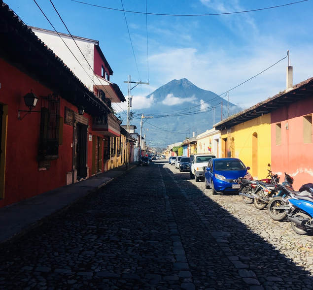
Antigua Guatemala means "Old Guatemala" and was the third capital of Guatemala. The first capital of Guatemala was founded on the site of a Kakchikel-Maya city, now called Iximche, on Monday, July 25, 1524—the day of Saint James—and therefore named Ciudad de Santiago de los Caballeros de Goathemalan (City of Saint James of the Knights of Guatemala). Naturally, St. James became the patron saint of the city.
Façade of the former El Carmen church After several Cakchiquel uprisings, the capital was moved to a more suitable site in the Valley of Alotenango (Rio Guacalate) on November 22, 1527, and kept its original name. This new city was located on the site of present-day San Miguel Escobar, which is a neighborhood in the municipality of Ciudad Vieja. This city was destroyed on September 11, 1541 by a devastating lahar from the Volcán de Agua. As a result, the colonial authorities decided to move the capital once more, this time five miles away to the Panchoy Valley. So, on March 10, 1543 the Spanish conquistadors founded present-day Antigua, and again, it was named Santiago de los Caballeros. For more than 200 years it served as the seat of the military governor of theSpanish colony of Guatemala, a large region that included almost all of present-day Central America and the southernmost State of Mexico: Chiapas. In 1566 King Felipe II of Spain gave it the title of "Muy Noble y Muy Leal" ("Very Noble and Very Loyal").
Population: The city had a peak population of some 60,000 in the 1770s; the bulk of the population moved away in the late 18th century. Despite significant population growth in the late 20th century, the city had only reached half that number by the 1990s. According to the 2007 census, the city has some 34,685 inhabitants.

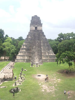
Tikal (or Tik’al according to the modern Mayan orthography) is one of the largest archaeological sites and urban centers of the pre-Columbian Maya civilization. It is located in the archaeological region of the Petén Basin in what is now northern Guatemala. Situated in the department of El Petén, the site is part of Guatemala's Tikal National Park and in 1979 it was declared a UNESCO World Heritage Site.
Tikal was the capital of a conquest state that became one of the most powerful kingdoms of the ancient Maya. Though monumental architecture at the site dates back as far as the 4th century BC, Tikal reached its apogee during the Classic Period, ca. 200 to 900 AD. During this time, the city dominated much of the Maya region politically, economically, and militarily, while interacting with areas throughout Mesoamerica such as the great metropolis of Teotihuacan in the distant Valley of Mexico. There is evidence that Tikal was conquered by Teotihuacan in the 4th century AD. Following the end of the Late Classic Period, no new major monuments were built at Tikal and there is evidence that elite palaces were burned. These events were coupled with a gradual population decline, culminating with the site’s abandonment by the end of the 10th century.
Tikal is the best understood of any of the large lowland Maya cities, with a long dynastic ruler list, the discovery of the tombs of many of the rulers on this list and the investigation of their monuments, temples and palaces
We will spend a day learning all about the coffee industry, from the farmers perspective. We will also likely spend some time working in the fields with a few of the farmers, potentially working in their homes or with the local artisans. This portion of the trip is about understanding the source of the products we buy and use and about being informed and responsible consumers. In addition to working with the coffee cooperative we're also hoping to have a chance to spend a couple hours with the founder of Valhalla Macadamia Nut Farms to better understand the agricultural market.
